
Home / Case studies / Radar reef imaging
Tech-Log™ · Platinum · underground
Radar off-hole imaging
of a platinum reef
Borehole radar run in a hole drilled subparallel to a platinum reef imaged the reef, fractures and voids up to about 30 m from the hole. The fractures carried methane, so the mining team could destress ahead of intersection and the geological model of the reef was revised.
The question
The client needed to accurately detect and locate methane-bearing structures in a platinum mine. Methane is a significant safety concern because of its potential to cause explosions during mining operations. Gas conduits such as fractures, voids and faulting are among the structures that can facilitate methane movement.
At the same time, the character of the reef itself, its lateral and vertical changes, needed to be mapped away from the borehole to improve the geological model. Conventional drilling samples only the hole; structures a few metres off the hole go unseen until mining reaches them.
Borehole radar detected and imaged gas-bearing fractures and voids relative to the platinum reef, so mining could be planned and destressed ahead of intersection, and the reef model was revised from evidence rather than assumption.
- SettingChromitite reefs of the Bushveld Igneous Complex
- ToolBorehole radar (BHR), omnidirectional transmitter and receiver
- RangeImaged to about 50 m, anomalous responses to about 30 m
- DetectedPlatinum-bearing chromitite reefs, fractures, voids, methane at fracture intersections
What we did
Borehole radar is an electromagnetic technique for imaging or detecting discontinuities in resistive hard-rock formations. It was deployed through a borehole drilled subparallel to the platinum reef. Radar reflections are caused by sharp changes in the electrical properties of the rock and yield information on lithology contacts, fractures, faults, voids, dykes and ore-body geometry.
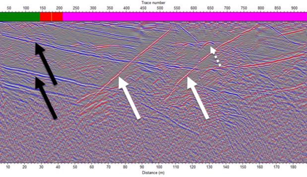
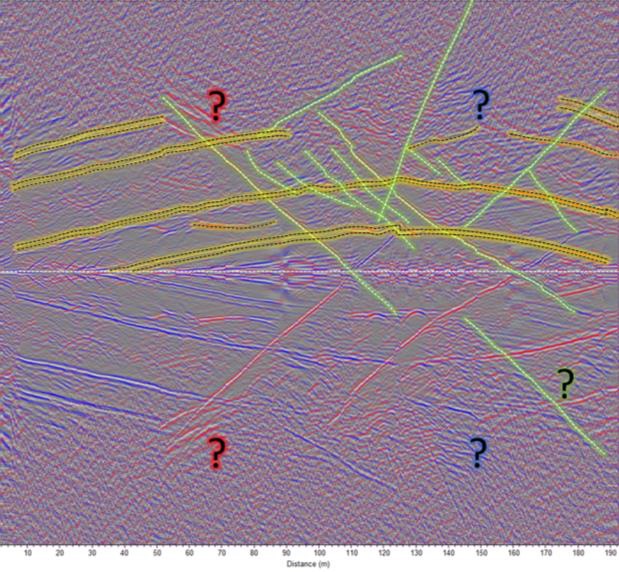
The radar section, with geology overlaid, imaged to a radial range of approximately 50 m from the borehole, with anomalous responses observed to about 30 m. Several features were detected: platinum-bearing chromitite reefs, fractures and voids. The fractures that were imaged showed methane gas at their intersection with the hole.
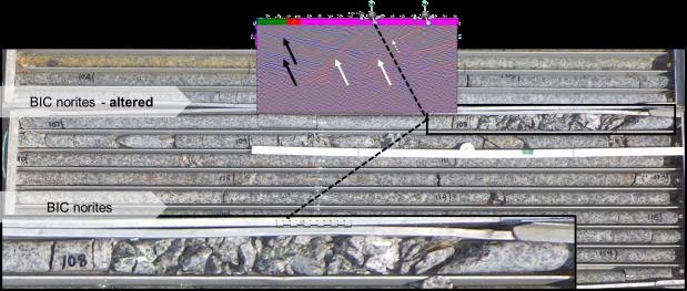
Diamond core from the intersection depths associated with the radar reflections showed brittle deformation and structure, with reduced competent core recovery, low RQD and discing, but little visible alteration. With prior knowledge of the predominant structural orientations, the lithological contacts and cross-cutting brittle structures were interpreted confidently in 3D on a vertical section.
What it changed
The radar results were used to mine safely by informing the mining team in advance of where mining would intersect gas-bearing structures. Conventional interventions, destressing or depressurising the volume ahead of mining by destress blasting, could then be planned to avoid rock bursts and blowouts. The findings played a crucial role in modifying the geological model of the reef.
- Methane-bearing fractures and voids located before mining reached them
- Lateral and vertical changes in the reef mapped up to 30 m off-hole
- Geological model of the reef revised
- Destress blasting planned on evidence, not on surprise intersections
The radar system consists of an omnidirectional transmitter and receiver oriented along the borehole axis. A high-frequency electromagnetic pulse propagates radially into the formation; energy is reflected back to the receiver wherever the dielectric permittivity changes rapidly, at lithological contacts, faults and fractures. The result is a 2D radargram, a composite image of the omnidirectional reflection events.